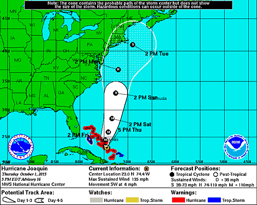
T he track currently forecast for Hurricane Joaquin — which has been upgraded to a Category 4 storm with maximum sustained winds of 130 miles per hour and wind gusts up to 155 miles per hour — now shifts east of the track which was predicted fewer than 24 hours ago, which means the brunt of the storm is expected to stay away from the mainland United States and is currently on track for possible landfall in Nova Scotia as a tropical depression…
…but while that might seem to be a reason to breathe a sigh of relief, it could actually mean more problems over a greater area — from South Carolina to Nova Scotia — through Wednesday.
One of the potential threats is the possibility of “historic” floods which could devastate certain regions of the United States — even those which may not be directly impacted by the storm — similar to the effects caused by Superstorm Sandy on October 29, 2012, which was the equivalent of a Category 1 hurricane at the time of landfall at Brigantine, New Jersey near Atlantic City but caused major damage to New York City and surrounding areas located north of the storm.
A state of emergency has been declared for all 100 counties in North Carolina by its governor, Pat McCrory, due to the amount of significant rainfall forecast for the region. For the same reason, the state of Maryland has been declared a state of emergency by its governor, Larry Hogan; and a state of emergency has been declared for New Jersey by its governor, Chris Christie.
Hurricane Joaquin is currently battering the central Bahamas; and a tropical storm warning has been issued for eastern Cuba.
One of the reasons for the adjusted track is due to strong steering currents — in coordination with a cold front and a low pressure system over the southeastern United States — which should help to prevent a direct landfall of the hurricane on the shoreline of the mainland United States; but keep in mind that the north side of the storm is the dangerous part due to the counterclockwise circulation of tropical systems in the northern hemisphere. This means that any potential destruction or damage should occur along the coast ahead of the center of the storm as it passes over the ocean adjacent to the coastline…
…and this is why strong winds, pounding surf, heavy rainfall and potentially devastating flooding is not only possible; but many areas along the coast of the eastern United States and extreme eastern Canada from South Carolina to Nova Scotia can be adversely affected by Hurricane Joaquin — as opposed to a more concentrated area suffering from a direct landfall, as was originally forecast. This means that if you intend to travel to any of those areas in the eastern United States and eastern Canada over the next few days, you need to keep yourself informed with the latest updates.
I am working on another update in the meantime to assist you with keeping up to date. Please stay tuned…
Source of graphic: the National Hurricane Center of the National Weather Service of the National Oceanic and Atmospheric Administration of the United States.

