

Because Hurricane Melissa slams Jamaica with gusty winds and significant precipitation, you may want to consider delaying your travel for the remainder of October of 2025 — or, at least, keep yourself updated as to the latest information pertaining to the weather — if Jamaica is in your travel plans.
Hurricane Melissa Slams Jamaica; Landfall Still Has Not Occurred: October 2025 Travel Alert
Maximum sustained winds of Hurricane Melissa — which is currently approximately 145 miles southwest of Kingston in Jamaica and moving west at a speed of three miles per hour — are at 165 miles per hour, which means that it is a Category 5 hurricane. Landfall is expected to occur somewhere along the coast of southern Jamaica as soon as early tomorrow morning, Tuesday, October 28, 2025. This dangerous storm will turn northward prior to its aforementioned first landfall in Jamaica as either a Category 5 hurricane or a very strong Category 4 hurricane.
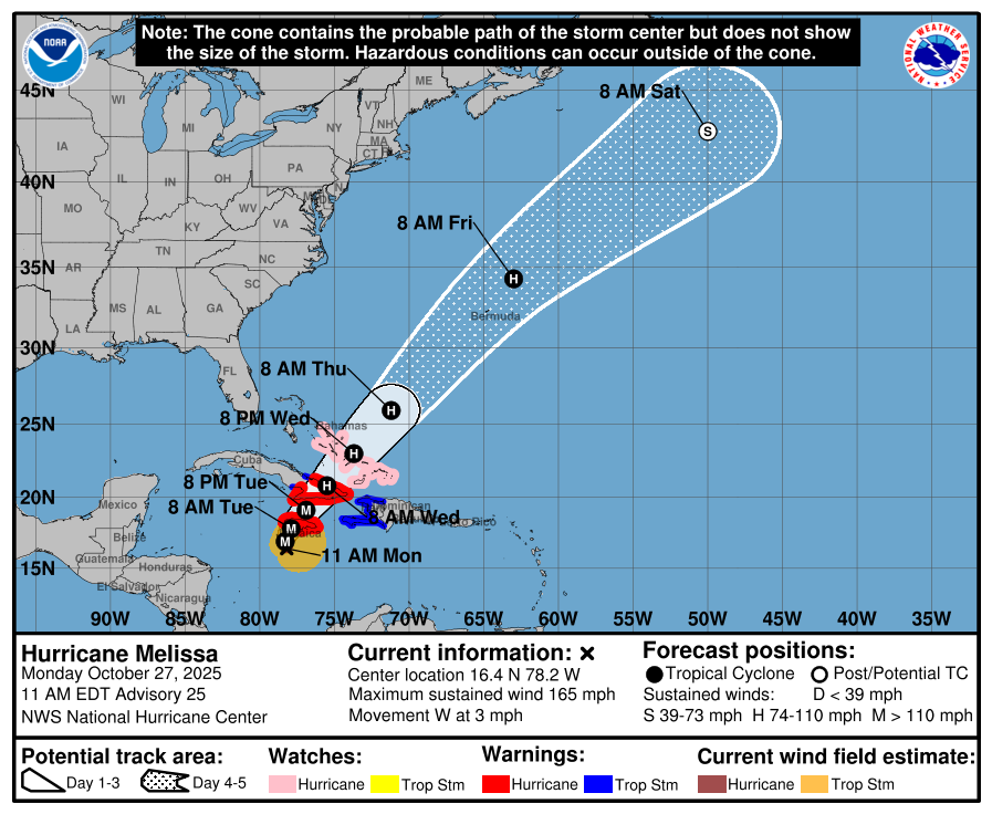
Because of its very slow forward movement, Hurricane Melissa will inundate the entire country of Jamaica and much of Haiti with both torrential rain and a storm surge. Windy conditions — especially on the east side of the storm — will only further exacerbate the situation.
Sangster International Airport — which serves Montego Bay in Jamaica— is currently closed due to Hurricane Melissa. No date and time has yet been set as to when the airport will resume operations.
A Hurricane Warning is in effect for:
- Jamaica
- The provinces of Granma, Santiago de Cuba, Guantanamo, and Holguin in Cuba
A Hurricane Watch is in effect for:
- Southeastern and central Bahamas
- Turks and Caicos Islands
A Tropical Storm Warning is in effect for:
- Haiti
- The province of Las Tunas in Cuba
Substantial precipitation of up to 46 inches is possible across portions of southwestern Haiti and eastern Jamaica, which is expected to result in potentially catastrophic urban flooding and flash flooding that can threaten lives.
Rough surf and strong rip currents are currently affecting much of the coasts of Jamaica, Haiti, Dominican Republic, and Cuba. A dangerous storm surge of possibly as high as 13 feet above normal is expected to contribute to the aforementioned significant flooding with potentially destructive large waves.
Expect windy conditions to occur over much of Jamaica and Haiti. An isolated tornado is possible in these areas.
After landfall in Jamaica, the storm is expected to head north northeast towards the southeastern coast of Cuba, where a second landfall is expected as soon as tomorrow evening, Tuesday, October 28, 2025. The Bahamas will be next after the storm crosses over Cuba.
Flight Waivers, Delays, and Cancellations
If you are traveling to or from Jamaica over the next few days, expect delays and cancellations of flights. Keep up to date on the latest information pertaining to this tropical weather system which may adversely affect your travel plans. Better yet, postponing or canceling your trip might be a better option — no matter which mode of travel you plan on taking.

If you have a flight scheduled, your flight may be delayed or canceled — and you may be eligible for a waiver of a fee to change your itinerary. If you are driving in any of these areas, watch out for deteriorating weather conditions and traffic problems.
Here are twelve airlines which have issued travel alerts as a result of this tropical weather system:
- American Airlines has issued travel alerts for eight airports in four countries for Saturday, October 25, 2025 through Wednesday, October 29, 2025; and Saturday, November 1, 2025 is the last day on which tickets must be reissued and rebooked travel must begin.
- Delta Air Lines has issued travel alerts for Kingston and Montego Bay for Saturday, October 25, 2025 through Tuesday, October 28, 2025; and Friday, October 31, 2025 is the last day on which tickets must be reissued and rebooked travel must begin.
- United Airlines has issued travel alerts for Montego Bay and Providenciales for Saturday, October 25, 2025 through Wednesday, October 29, 2025; and Wednesday, November 5, 2025 is the last day on which tickets must be reissued and rebooked travel must begin.
- Southwest Airlines has issued a travel alert for Montego Bay for Saturday, October 25, 2025 through Wednesday, October 29, 2025; and Saturday, November 8, 2025 is the last day on which tickets must be reissued and rebooked travel must begin.
- JetBlue Airways has issued travel alerts for Kingston and Montego Bay for Saturday, October 25, 2025 through Friday, October 31, 2025; and Saturday, November 8, 2025 is the last day on which tickets must be reissued and rebooked travel must begin.
- Frontier Airlines has issued travel alerts for Kingston and Montego Bay for Thursday, October 23, 2025 through Monday, October 27, 2025.
- Spirit Airlines has issued travel alerts for Kingston and Montego Bay for Friday, October 24, 2025 through Tuesday, October 28, 2025; and Monday, November 3, 2025 is the last day on which tickets must be reissued and rebooked travel must begin.
- Caribbean Airlines has issued travel alerts for Kingston and Montego Bay for Tuesday, October 28, 2025; and Thursday, November 20, 2025 is the last day on which tickets must be reissued and rebooked travel must begin.
- Copa Airlines has issued travel alerts for Kingston and Montego Bay for Monday, October 27, 2025 through Tuesday, October 28, 2025; and Monday, November 3, 2025 is the last day on which tickets must be reissued and rebooked travel must begin.
- Air Canada has issued travel alerts for:
- Montego Bay for Monday, October 27, 2025.
- Cayo Coco, Kingston, Montego Bay, San Salvador, and Varadero for Tuesday, October 28, 2025.
- Cayo Coco, Kingston, Montego Bay, Providenciales, and Varadero for Wednesday, October 29, 2025.
- WestJet Airways has issued travel alerts for:
- Kingston and Montego Bay for Saturday, October 25, 2025 through Friday, October 29, 2025.
- Holguín in Cuba for Monday, October 27, 2025 through Friday, October 29, 2025.
- KLM Royal Dutch Airlines has issued travel alerts for Kingston and Montego Bay for Saturday, October 25, 2025 through Tuesday, October 28, 2025; and Friday, October 31, 2025 is the last day on which tickets must be reissued and rebooked travel must begin.
Final Boarding Call
I wanted to check the radar for more visual details on Hurricane Melissa…
…but the federal government of the United States is currently shut down and closed. Oh, well…
Be sure to contact your airline or transportation provider for the latest information pertaining to your travels — if they are adversely affected — and please: travel safely.
Photograph ©2024 by Brian Cohen.
