

Hurricane Milton is now a strong Category 5 hurricane as of today, Monday, October 7, 2024 — which is currently tied as the third strongest hurricane in the history of the Atlantic basin — and that does not bode well for the greater Tampa Bay metropolitan area, which is almost certain to be hit head on with the landfall of this dangerous tropical cyclone.
Hurricane Milton Now a Strong Category 5 Hurricane: October 2024 Travel Alert
Maximum sustained winds of Hurricane Milton — which is currently approximately 650 miles west southwest of Tampa in Florida and moving east at a speed of ten miles per hour — are at 180 miles per hour, which means that it is currently a strong Category 5 hurricane. The speed of wind gusts are likely exceeding 220 miles per hour.
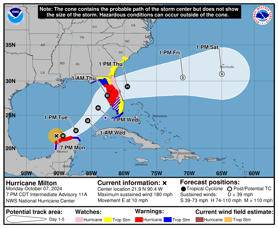
Forecasts call for the landfall of Hurricane Milton to occur as a major hurricane at the greater metropolitan area of Tampa Bay in Florida as early as the evening of Wednesday, October 9, 2024 — and if it stays on track, this will be the worst storm to impact the greater metropolitan area of Tampa Bay in at least 100 years.
The main reason why Hurricane Milton rapidly intensified is because the waters of the Gulf of Mexico are warmer than normal due to the lack of cyclonic activity this year. That no other weather feature — such as a cold front — inhibited its development certainly did not help.
Hurricane Helene also rapidly developed in a similar manner; but it took a complete different track than Hurricane Milton is currently taking — so much of the time that Hurricane Milton tracks northeast across the Gulf of Mexico will be mostly over abnormally warm waters that helped fuel it to quickly become a Category 5 hurricane earlier today, Monday, October 7, 2024.

The official satellite loop from the The National Oceanic and Atmospheric Administration of the Department of Commerce of the United States clearly shows that the eye of Hurricane Milton is small and well defined, which is one feature of a powerful tropical cyclone. Another sign is the barometric pressure, which is currently at 897 millibars for Hurricane Milton. For comparison purposes, the lowest barometric pressure that was ever recorded in the history of our planet for a tropical cyclone was 870 millibars for Typhoon Tip in October of 1979. Hurricane Katrina in 2005 was at 902 millibars of barometric pressure with maximum sustained winds of 175 miles per hour.
Significant precipitation from the outflow of Hurricane Milton is already occurring in much of the state of Florida.
A state of emergency has been declared in 51 counties of the state of Florida by Ron DeSantis, who is the current governor of the state.
Mandatory evacuations have been ordered in Tampa and other areas of Florida — as part of what may possibly be the largest evacuation order since Hurricane Irma in 2017 — which expect to be impacted by Hurricane Milton. If you are in the path of this hurricane, take action immediately to evacuate to a safer location and follow the advice that is outlined by the Federal Emergency Management Agency of the Department of Homeland Security of the United States.
To help facilitate evacuations for #HurricaneMilton, Emergency Shoulder Use (ESU) plans are actively being put in place for Eastbound I-4 and portions of Northbound I-75. Law enforcement and signage will alert motorists on when to enter and exit the shoulder. Learn more about ESU… pic.twitter.com/55RxNvizOJ
— FLORIDA DOT (@MyFDOT) October 7, 2024
The eastbound lanes of Interstate 4 and the northbound lanes of both Interstate 75 and Interstate 275 have been clogged with traffic. To help ease evacuation efforts, tolls have been suspended on many toll roads throughout the state — as well as the emergency opening of shoulder lanes for increased capacity of traffic.
Here is I-75 as thousands evacuate from Tampa. Major Hurricane Milton. Traffic is a standstill. #HurricaneMilton #hurricane #tropics #GFS pic.twitter.com/pCUuftDf4B
— CollinRL (@CollinRLwx) October 7, 2024
NEW VIDEO: Hillsborough County Sheriff shows evacuation traffic ahead of #Milton on I-75 between Morris Bridge and Bruce B Downs. #FLwx pic.twitter.com/q2TFUrFW5n
— The Hurricane Network (@TheHurricaneNet) October 7, 2024
Supplies have been exhausted at an increasing number of supermarkets and home improvement stores. Dining establishments have been running out of food. Long queues have been forming at fuel stations across the state — only for motorists to find that the pumps no longer have regular gasoline available for sale.
My son is in Hernando County FL. These are after Helene. Now Milton is heading for them. Everywhere is out of gas & roads are too backed up for him to evaluate. He has family in GA but can't get there. This is scary. He is scared. I am terrified for him. pic.twitter.com/S7NsrTlChW
— Amanda Michelle (@LucyMay1983) October 7, 2024
https://twitter.com/thinktankfranks/status/1843371921955795034
In addition to substantially strong sustained winds for areas that will be close to the eye of the hurricane, another factor will be the inundating torrential rains and flooding — especially for areas that are on the south and east side of the hurricane because of the counterclockwise motion of the storm, which will “shovel” the rain and gulf water onto western Florida. Thus, the landfall of the eye of the hurricane will be better for the city of Tampa if it occurs south of Tampa Bay rather than north.
A Hurricane Warning is in effect from:
- Celestun to Rio Lagartos
- The west coast of Florida from Bonita Beach northward to the mouth of the Suwannee River — including Tampa Bay
A Hurricane Watch is in effect from:
- Rio Lagartos to Cabo Catoche
- Campeche to south of Celestun
- Dry Tortugas
- Lake Okeechobee
- The west coast of Florida from Chokoloskee to south of Bonita Beach
- The east coast of Florida from the border which the counties of Saint Lucie and Indian River share northward to the mouth of the Saint Marys River
A Tropical Storm Warning is in effect from:
- Rio Lagartos to Cancun
- Campeche to south of Celestun
- All of the Florida Keys — including Dry Tortugas
- Lake Okeechobee
- The west coast of Florida from Flamingo to south of Bonita Beach
- The west coast of Florida from from north of the mouth of the Suwanee River to Indian Pass
A Tropical Storm Watch is in effect from:
- East coast of the Florida Peninsula south of the border which the counties of Saint Lucie and Indian River share southward to Flamingo
- Coast of Georgia and South Carolina from north of the mouth of the Saint Marys River to South Santee River in South Carolina
A Storm Surge Watch is in effect from:
- Sebastian Inlet to Edisto Beach, including St. Johns River
Significant precipitation of up to 15 inches is possible in across portions of much of the state of Florida, which is expected to result in substantial urban flooding and flash flooding.

Rough surf and strong rip currents will gradually affect much of the southeastern United States as Hurricane Milton approaches. A storm surge of as high as 20 feet above normal is expected to contribute to the aforementioned substantial flooding of portions of Florida.
Expect windy conditions to occur over much of the state of Florida and as far north as eastern South Carolina. Electric power lines will be affected and cause tens of thousands of people to temporarily be without electrical power, which could last for weeks. Trees will also fall because of both soil that is too wet to support them and strong gusty winds, which could potentially exceed 200 miles per hour at the area of landfall. Isolated tornados are also likely in many areas.
Recovery of the areas which are hardest hit will likely take months to complete, as the repair of damage and clearing of debris from Hurricane Helene — which was not a direct hit on the peninsula of Florida — have not been close to completion.
Latest Update of Operations at Airports
Operations will officially be suspended at the following airports:
- Tampa International Airport at 9:00 in the morning tomorrow, Tuesday, October 8, 2024.
- Saint Petersburg-Clearwater International Airport after the last flight departs tomorrow, Tuesday, October 8, 2024. All flights have been cancelled for Wednesday, October 9, 2024 and Thursday, October 10, 2024.
- Sarasota Bradenton International Airport at 4:00 in the afternoon tomorrow, Tuesday, October 8, 2024.
- Orlando International Airport at 8:00 in the morning on Wednesday, October 9, 2024.
- Southwest Florida International Airport is technically not closing, as most airlines are planning to operate tomorrow, Tuesday, October 8, 2024 — but no commercial flights will be operating on Wednesday, October 9, 2024 and Thursday, October 10, 2024.
Airports which are monitoring the progress of Hurricane Milton at the time this article was written include:
- Daytona Beach International Airport
- Jacksonville International Airport
- Melbourne Orlando International Airport
- Gainesville Regional Airport
- Palm Beach International Airport
- Miami International Airport
- Key West International Airport
- Savannah Hilton Head International Airport
Flight Waivers, Delays, and Cancellations
If you are traveling to or from many areas of Florida, expect delays and cancellations of flights. Keep up to date on the latest information pertaining to this tropical weather system which may adversely affect your travel plans. Better yet, postponing or canceling your trip might be a better option — no matter which mode of travel you plan on taking.
If you have a flight scheduled, your flight may be delayed or canceled — and you may be eligible for a waiver of a fee to change your itinerary. If you are driving in any of these areas, watch out for deteriorating weather conditions and traffic problems.
Here are 17 airlines which have issued travel alerts as a result of this tropical weather system:
- American Airlines has issued travel alerts for twelve airports in Florida for Tuesday, October 8, 2024 through Thursday, October 10, 2024; and Thursday, October 17, 2024 is the last day on which tickets must be reissued and rebooked travel must begin.
- Delta Air Lines has issued travel alerts for eight airports in Florida for Monday, October 7, 2024 through Thursday, October 10, 2024; and Tuesday, October 15, 2024 is the last day on which tickets must be reissued and rebooked travel must begin.
- United Airlines has issued travel alerts for five airports in Florida for Monday, October 7, 2024 through Thursday, October 10, 2024; and Thursday, October 17, 2024 is the last day on which tickets must be reissued and rebooked travel must begin.
- Alaska Airlines has issued travel alerts for Tampa, Orlando, and Fort Myers for Monday, October 7, 2024 through Thursday, October 10, 2024; and Thursday, October 17, 2024 is the last day on which tickets must be reissued and rebooked travel must begin.
- Southwest Airlines has issued travel alerts for four airports in Florida for Tuesday, October 8, 2024 through Thursday, October 10, 2024; and Thursday, October 24, 2024 is the last day on which tickets must be reissued and rebooked travel must begin.
- JetBlue Airways has issued travel alerts for four airports in Florida for Tuesday, October 8, 2024 through Thursday, October 10, 2024; and Sunday, October 13, 2024 is the last day on which tickets must be reissued and rebooked travel must begin.
- Frontier Airlines has issued travel alerts for Cancún and five airports in Florida for Monday, October 7, 2024 through Thursday, October 10, 2024.
- Spirit Airlines has issued travel alerts for Fort Myers, Orlando, and Tampa for Monday, October 7, 2024 through Thursday, October 10, 2024; and Thursday, October 17, 2024 is the last day on which tickets must be reissued and rebooked travel must begin.
- Allegiant Air has issued travel alerts for Sarasota, Saint Petersburg-Clearwater, and Punta Gorda starting on Tuesday, October 8, 2024.
- Sun Country Airlines has issued travel alerts for six airports in Florida for Monday, October 7, 2024 through Thursday, October 10, 2024; and Thursday, October 17, 2024 is the last day on which tickets must be reissued and rebooked travel must begin.
- Breeze Airways has issued travel alerts for seven airports in Florida for Monday, October 7, 2024 through Thursday, October 10, 2024; and Thursday, October 24, 2024 is the last day on which tickets must be reissued and rebooked travel must begin.
- Silver Airways has issued travel alerts for Key West, Tampa, and Orlando for Tuesday, October 8, 2024 through Thursday, October 10, 2024; and Thursday, October 17, 2024 is the last day on which tickets must be reissued and rebooked travel must begin.
- Air Canada has issued travel alerts for:
- Cancún for Monday, October 7, 2024 through Tuesday, October 8, 2024.
- Five airports in Florida for Monday, October 7, 2024 through Thursday, October 10, 2024.
- Aeromexico has issued travel alerts for:
- Mérida for Monday, October 7, 2024 through Tuesday, October 8, 2024; and Monday, October 14, 2024 is the last day on which tickets must be reissued and rebooked travel must begin.
- Tampa, Miami, and Orlando for Tuesday, October 8, 2024 through Thursday, October 10, 2024; and Monday, October 14, 2024 is the last day on which tickets must be reissued and rebooked travel must begin.
- Cayman Airways has issued travel alerts for Tampa and Miami for Sunday, October 6, 2024 through Friday, October 11, 2024; and Wednesday, October 16, 2024 is the last day on which tickets must be reissued and rebooked travel must begin.
- KLM Royal Dutch Airlines has issued travel alerts for eight airports in Florida for Monday, October 7, 2024 through Wednesday, October 9, 2024; and Saturday, October 12, 2024 is the last day on which tickets must be reissued and rebooked travel must begin.
- Virgin Atlantic Airways has issued travel alerts for eight airports in Florida for Monday, October 7, 2024 through Thursday, October 10, 2024; and Saturday, October 19, 2024 is the last day on which tickets must be reissued and rebooked travel must begin.
Final Boarding Call
If you are currently in Florida, get out now. You are in grave danger if you decide not to evacuate — especially if you are near the western coast of the state. Even if you survive the impacts of the hurricane itself, the area in which you are located could be inhabitable for months with no electric power, no fuel, no materials for repairs, and no provisions; and you may be trapped there. Rescuers may not be able to get to you. Do not travel to central Florida until further notice. Hurricane Milton may possibly weaken prior to landfall — but even if it weakens significantly to a Category 3 hurricane, widespread catastrophic destruction is still likely.
https://twitter.com/GuerreroKaylie/status/1843353413419172326
By the way, Category 5 is the highest category on the Saffir-Simpson Scale. Category 6 does not exist.
Be sure to contact your airline or transportation provider for the latest information pertaining to your travels — if they are adversely affected — and please: travel safely.
As for the people who will be impacted by Hurricane Milton: my thoughts and prayers are with you…
Photograph ©2024 by Brian Cohen.
