A portion of Interstate 85 in Atlanta is currently closed until further notice due to the collapse of a section of the northbound lanes as the result of what has been called a “raging inferno”: a fire so intense that the heat compromised the viaduct which supports the highway.
Because of that, both directions of Interstate 85 between Interstate 75 and United States Highway 19 — more popularly known in Atlanta as Georgia State Highway 400 — are closed until further notice; but the rebuilding of that portion of the highway is expected to take several months, as three full sections of Interstate 85 will need to be removed and replaced in addition to section which collapsed.
Nathan Deal — who is the current governor of Georgia — declared a state of emergency for Fulton County, in which much of the city of Atlanta is located. Federal funds will help to pay for the repairing and rebuilding of the affected portion of Interstate 85.
Navigating Atlanta — and What Was Under That Collapsed Portion of Highway?
What prompted the fire? A “tweet” from a viewer of WSB-TV Channel 2 Action News in Atlanta shows storage of what appears to be dozens of giant spools of cable in an area underneath the highway at Piedmont Road which was somewhat secured by a chain link fence.
JUST IN: A viewer sent us this photo of the fire as it started underneath I-85. It has now caused part of the road to collapse. Live on CH 2 pic.twitter.com/7VjGyAfedR
— WSB-TV (@wsbtv) March 30, 2017
In the photograph shown above, the Buford Connector is in the background; and you can see vehicles traveling on it…

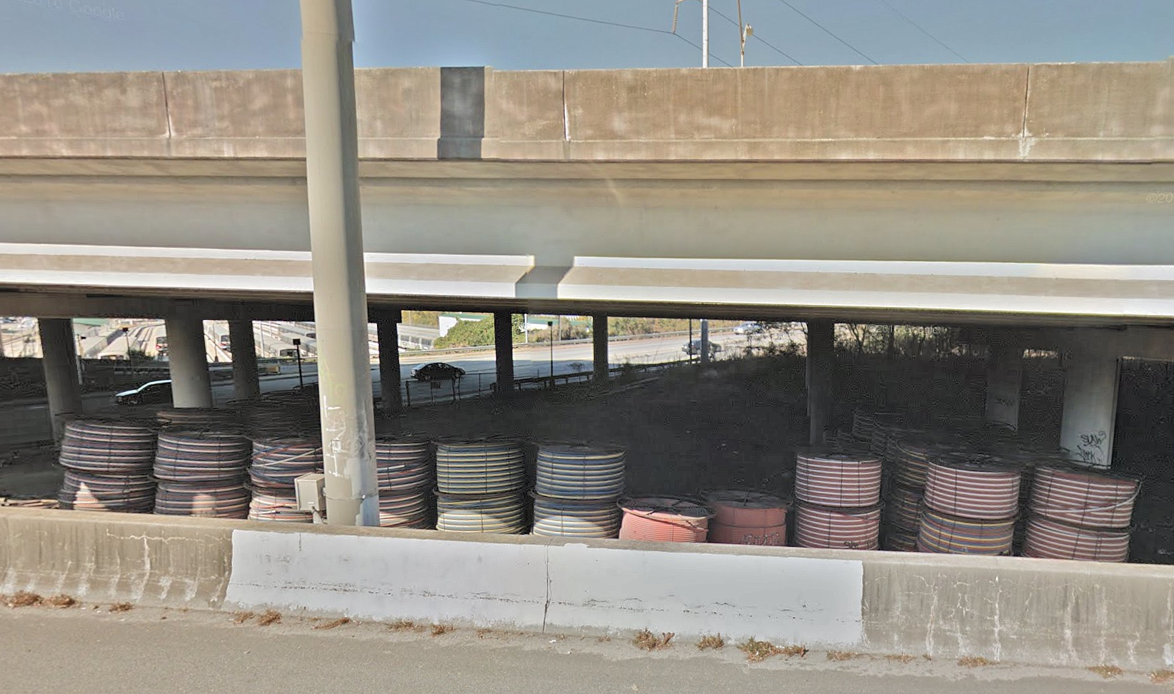
…so I used Google Maps to see what underneath Interstate 85 looked like prior to the fire; and literally dozens of spools were stored there. According to this official press release from Russell R. McMurry — who is the commissioner of the Georgia Department of Transportation — “The area in which the fire originated is part of the state’s right of way that was utilized as a storage location for construction materials, equipment and supplies. The site was a secured area containing materials such as PVC piping which is a stable, non-combustible material. We are as eager to learn the cause of this fire as anyone, which is why we will continue to work closely and in full cooperation with fire investigators to determine exactly how the fire was started.”
The bridge over Piedmont Road was built in 1953 and was last reconstructed in 1985, according to this article written by Jennifer Peebles of the Atlanta Journal-Constitution; and it received a “sufficiency rating” of 94.6 on a scale of 1 to 100 in its most recent inspection in 2015. “Its deck was rated as very good, while its superstructure and substructures were rated good.”
Navigating Atlanta
The Georgia Department of Transportation gives some guidance on how to navigate Atlanta while Interstate 85 is closed with two maps.


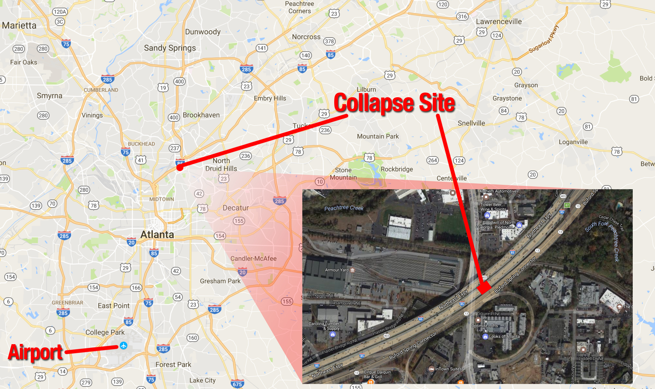
The international airport which serves the greater Atlanta metropolitan area is located south of Interstate 20; so if you are traveling to downtown Atlanta or northward towards Cobb County, you will not need to take an alternate route — other than if traffic is unbearably heavy.
The Buford-Spring Connector — which this section of Georgia State Highway 13 is better known as in Atlanta and runs parallel to Interstate 85 in this area — will be open again to traffic at 2:00 in the afternoon Eastern Daylight Time; but even though it could be a viable alternative, it unfortunately will not be accessible from Interstate 85.
- Interstate 85 is closed from Interstate 75 — the area is known as the Brookwood split — to the North Druid Hills Road exit
- Motorists traveling northbound on Interstate 85 from the south side of Atlanta will be diverted to Interstate 75 northbound at Brookwood near 17 Street
- Motorists traveling southbound on Interstate 85 north of Atlanta will be diverted to northbound on United States Highway 19, which is more popularly known in Atlanta as Georgia State Highway 400
- Motorists traveling southbound on Georgia State Highway 400 from north of Atlanta will be diverted at the Sidney Marcus Boulevard exit
Summary
I never really did understand why that portion of Interstate 85 was elevated. Underneath it is either parking spaces; storage of items such as those spools of cable; the Highway Emergency Response Operators — or HERO — unit of the Georgia Department of Transportation; or what seems to be some sort of an access road.
Something is not sitting right with me with regard to statements pertaining to the cause of the fire. I cannot explain why; but if those materials stored under the highway were comprised of a “stable, non-combustible material”, then why was the fire so intense that it compromised the structure supporting the highway and took at least eleven hours to completely extinguish?
As for navigating around Atlanta, fortunately there are a number of options — albeit many choked with traffic under normal circumstances. If you intend to travel to the Buckhead area, you can take Interstate 75 to West Paces Ferry Road on which you can head east; and if you are going towards Gwinnett County or South Carolina or points northeastward, you can either travel on Interstate 20 east to Interstate 285 north to Interstate 85 north — but ensure you leave yourself enough time on this route.
From the international airport which serves the greater Atlanta metropolitan area, your best bet is Interstate 285 — also known as the Perimeter — which circles Atlanta. Take Interstate 285 north to head towards Cobb County and states such as Tennessee and Alabama; and take Interstate 285 east to head towards Gwinnett County or South Carolina or points northeastward. If you are heading directly into downtown Atlanta, take Interstate 85 north as usual, as the affected area is not en route.
You can also use the Metropolitan Atlanta Rapid Transit Authority — which is known more popularly as MARTA, which is the transit system of Atlanta: “Due to the recent I-85 collapse, MARTA is providing additional services to accommodate the expected influx of passengers needing to navigate traffic congestion and delays. MARTA is increasing rail services to assist travelers during this time. Additional representatives are on hand to assist passengers as needed. MARTA continues to work closely with our state and local partners to ensure that residents and visitors can safely reach their destinations.”
Imagery ©2017 TerraMetrics. Map data ©2017 courtesy of Google Maps. Composite graphic illustration by Brian Cohen.
