
Do you know where the geographic centers of each state in the United States are located? The thought never even occurred to me until someone sent to me a humorous Instagram posting that I did not find all that funny — but I did start to wonder…
Geographic Centers of Each State in the United States
…and after an admittedly minimum effort of research, I found an official list of the geographic center of each state in the United States — as well as the District of Columbia — but territories of the United States are not included on the list.
However, do not count on its accuracy: “The geographic center of an area may be defined as the center of gravity of the surface, or that point on which the surface of an area would balance if it were a plane of uniform thickness”, according to this official web site of the United States Geological Survey of the Department of the Interior of the United States. “Because there is no generally accepted definition of a geographic center and no completely satisfactory method of determining it, there may be as many geographic centers of a State or county as there are definitions of the term.”
To complicate matters, islands that are adjacent to the coastlines of each state — as well as large bodies of water — were excluded in determining the center of each state.
Furthermore, curvature of the Earth, large bodies of water, irregular surfaces, and other factors affect the determination of center of gravity.
Therefore, the geographic centers and positions that are listed below should be considered as approximations and not as definitively accurate locations.
State |
County |
Locality |
|---|---|---|
| Alabama | Chilton | 12 miles southwest of Clanton |
| Alaska | 63°50′ North, 152°00′ West, 60 miles northwest of Mount McKinley | |
| Arizona | Yavapai | 55 miles east-southeast of Prescott |
| Arkansas | Pulaski | 12 miles northwest of Little Rock |
| California | Madera | 38 miles east of Madera |
| Colorado | Park | 30 miles northwest of Pikes Peak |
| Connecticut | Hartford | At East Berlin |
| Delaware | Kent | 11 miles south of Dover |
| District of Columbia | Near Fourth and L Streets Northwest | |
| Florida | Hernando | 12 miles north-northwest of Brooksville |
| Georgia | Twiggs | 18 miles southeast of Macon |
| Hawaii | Hawaii | 20°15′ North, 156°20′ West, off Maui Island |
| Idaho | Custer | At Custer, southwest of Challis |
| Illinois | Logan | 28 miles northeast of Springfield |
| Indiana | Boone | 14 miles north-northwest of Indianapolis |
| Iowa | Story | 5 miles northeast of Ames |
| Kansas | Barton | 15 miles northeast of Great Bend |
| Kentucky | Marion | 3 miles north-northwest of Lebanon |
| Louisiana | Avoyelles | 3 miles southeast of Marksville |
| Maine | Piscataquis | 18 miles north of Dover |
| Maryland | Prince Georges | 4.5 miles northwest of Davidsonville |
| Massachusetts | Worcester | North part of City of Worcester |
| Michigan | Wexford | 5 miles north-northwest of Cadillac |
| Minnesota | Crow Wing | 10 miles southwest of Brainerd |
| Mississippi | Leake | 9 miles west-northwest of Carthage |
| Missouri | Miller | 20 miles southwest of Jefferson City |
| Montana | Fergus | 11 miles west of Lewistown |
| Nebraska | Custer | 10 miles northwest of Broken Bow |
| Nevada | Lander | 26 miles southeast of Austin |
| New Hampshire | Belknap | 3 miles east of Ashland |
| New Jersey | Mercer | 5 miles southeast of Trenton |
| New Mexico | Torrance | 12 miles south-southwest of Willard |
| New York | Madison | 12 miles south of Oneida and 26 miles southwest of Utica |
| North Carolina | Chatham | 10 miles northwest of Sanford |
| North Dakota | Sheridan | 5 miles southwest of McClusky |
| Ohio | Delaware | 25 miles north-northeast of Columbus |
| Oklahoma | Oklahoma | 8 miles north of Oklahoma City |
| Oregon | Crook | 25 miles south-southeast of Prineville |
| Pennsylvania | Centre | 2.5 miles southwest of Bellefonte |
| Rhode Island | Kent | 1 mile south-southwest of Crompton |
| South Carolina | Richland | 13 miles southeast of Columbia |
| South Dakota | Hughes | 8 miles northeast of Pierre |
| Tennessee | Rutherford | 5 miles northeast of Murfreesboro |
| Texas | McCulloch | 15 miles northeast of Brady |
| Utah | Sanpete | 3 miles north of Manti |
| Vermont | Washington | 3 miles east of Roxbury |
| Virginia | Buckingham | 5 miles southwest of Buckingham |
| Washington | Chelan | 10 miles west-southwest of Wenatchee |
| West Virginia | Braxton | 4 miles east of Sutton |
| Wisconsin | Wood | 9 miles southeast of Marshfield |
| Wyoming | Fremont | 58 miles east-northeast of Lander |
Geographic Area |
Locality |
Latitude North |
Longitude West |
|---|---|---|---|
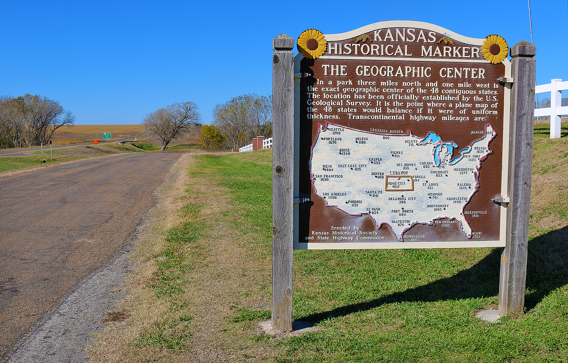
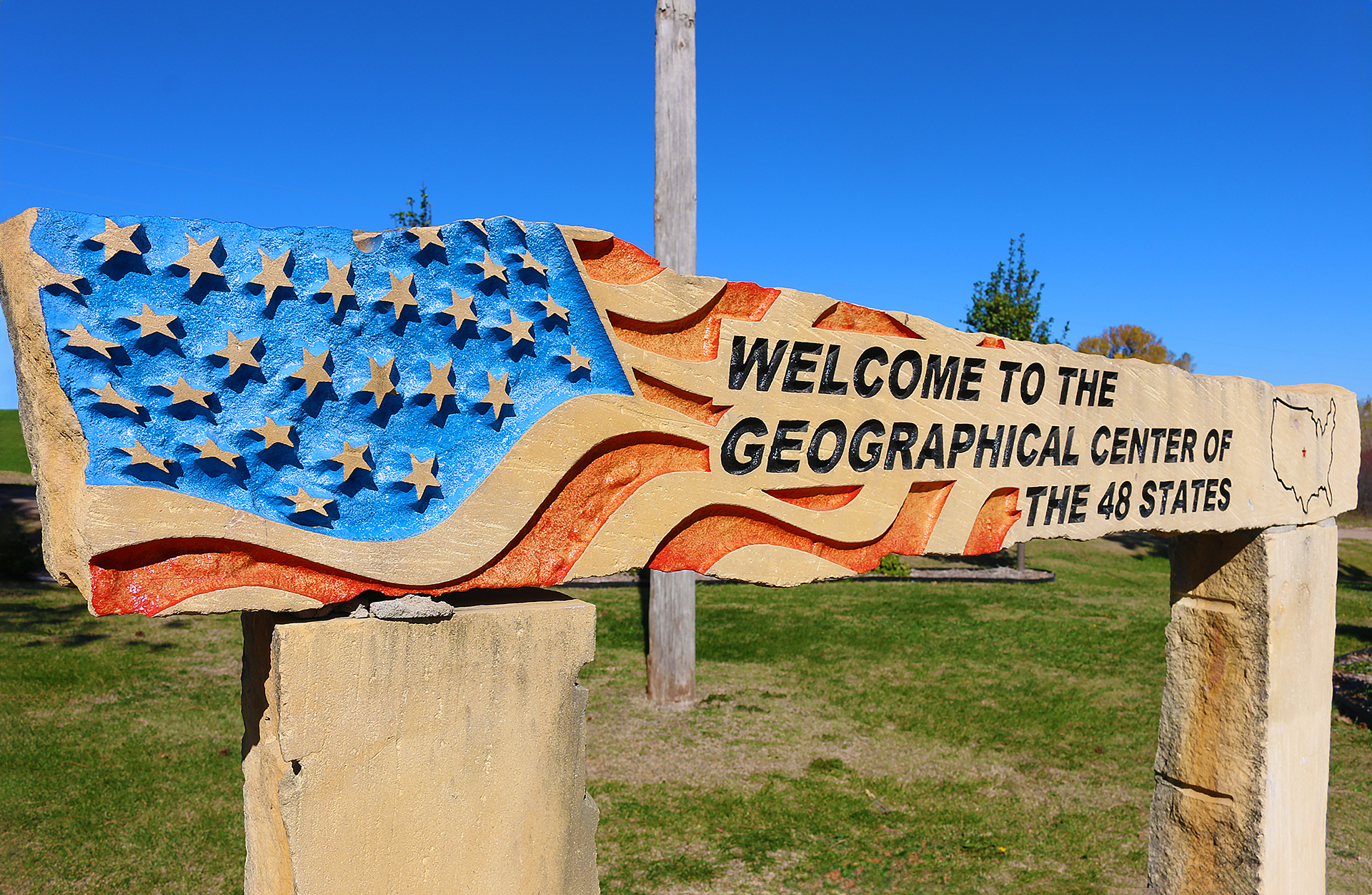
| Conterminous United States — 48 States | Near Lebanon, Smith County, Kansas | 39°50′ | 98°35′ |
| Continental United States — 49 States | Near Castle Rock, Butte County, South Dakota | 44°59′ | 103°38′ |
| The United States — 50 States | West of Castle Rock, Butte County, South Dakota | 44°58′ | 103°46′ |
| North American Continent | 6 miles west of Balta, Pierce County, North Dakota | 48°10′ | 100°10′ |
No marked location or monumented point has been officially established by any government agency as the geographic center of either the 50 states, the conterminous United States, or the North American continent…
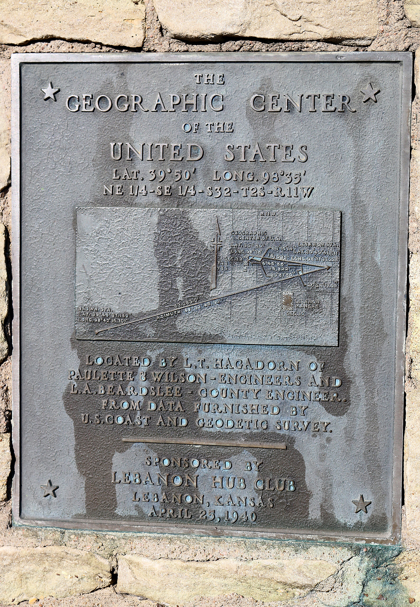
…but a monument was erected in Lebanon in Kansas on Thursday, April 25, 1940 by a group of citizens who hired engineers to determine the position of the “geographic center” of the United States as determined by what was then called the United States Coast and Geodetic Survey.
Sometimes confused with geographic center of the United States is the triangulation station “Meades Ranch”, which is located at latitude 39°13’26.686″ North and longitude 98°32’30.506″ West, approximately twelve miles north of Lucas in Kansas. This was the primary reference point for the North American Datum of 1927 — the standard on which all the latitude and longitude lines for North America were based…
…but that datum is being replaced by the North American Datum of 1983 from the National Geodetic Survey of the National Oceanic and Atmospheric Administration of the Department of Commerce of the United States, which is not hinged to a single point of reference.
Final Boarding Call
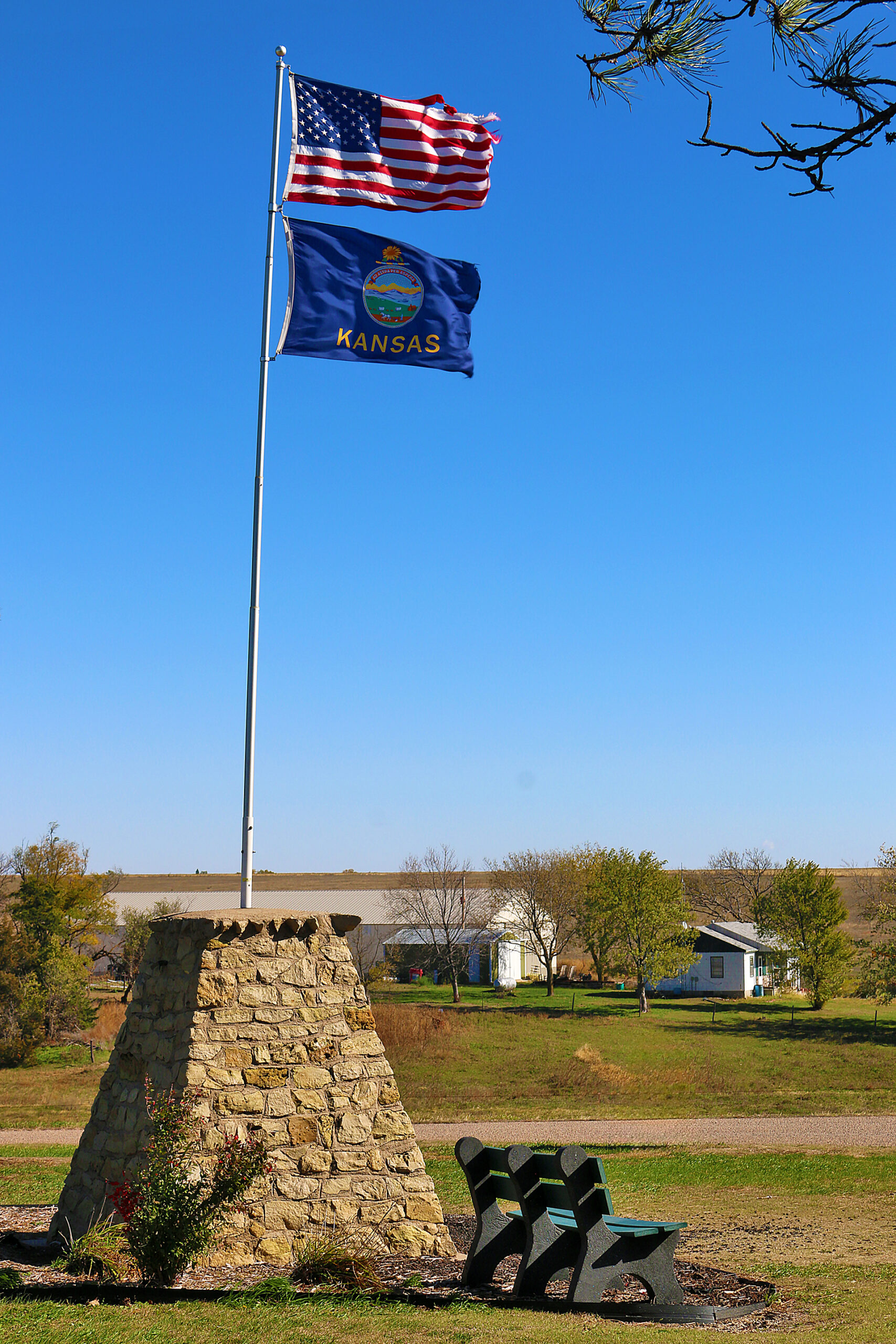
I have been to the geographical center of the 48 conterminous United States near Lebanon in Kansas — twice — and I have been near what was the unmarked geographical centers of both the 49 continental United States and all 50 states of the United States near Castle Rock in South Dakota, of which I was warned by a law enforcement officer not to go nearer because of a problem with snakes…

…but I have never knowing been to any of the other aforementioned places that are listed in the lists in this article.
Have you been to any of them?
All photographs ©2017 by Brian Cohen.
