Note: This article pertaining to Standing in the Middle of the Eastern End of Interstate 70 was originally published on Saturday, December 23, 2017 at 10:54 in the evening and has been updated.
Interstate 70 is one of the stranger major highways in the United States. For one example, its interchange in Breezewood in Pennsylvania loops around itself, with a traffic light at United States Highway 30 — one of the rare locations in which a traffic light interrupts the traffic flow of an interstate highway.
I have not yet been to Breezewood; so I have no photographs nor comments pertaining to actual experience with this interchange.
Standing in the Middle of the Eastern End of Interstate 70
Additionally, Interstate highways of which the last of two digits ends in zero usually cross the United States from at least one coast. Although Interstates 20, 30 and 40 are exceptions, they at least end at a road or highway…

…but the eastern terminus of Interstate 70 simply ends…

…with the eastbound traffic looping around to the westbound direction, as shown by the curve in the photograph.

Even the faded sign which marks this section of Interstate 70 is covered with so many leaves, branches and vines, it is difficult to read the sign — even up close.

The eastern end of Interstate 70 abruptly ends at the Gwynns Falls trailhead at Leakin Park.

The middle of the eastern terminus of Interstate 70 marks the easternmost end of the highway — which is the farthest east on Interstate 70 on which you can drive a vehicle — and the beginning of the trailhead…

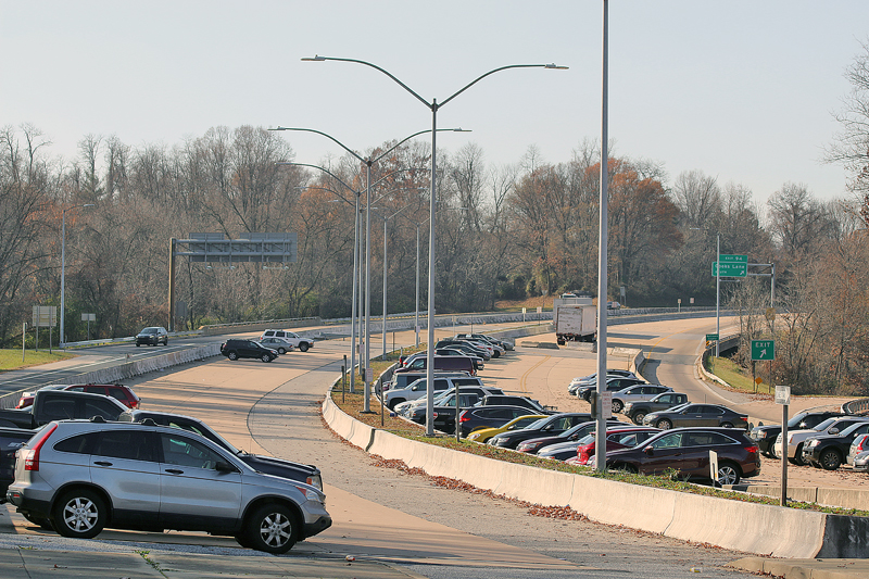
…but not before motorists pass a parking lot for commuters in the middle of the highway east of the interchange with Maryland State Highway 122.

Cooks Lane is the name of Maryland State Highway 122 south of Interstate 70; but its name changes to Security Boulevard north of Interstate 70.

I initially thought that this corner of pavement north of the middle of Interstate 70 where the trailhead begins was the farthest one can drive a vehicle on the highway…

…but because the highway curves towards east northeast at its very end, this corner of pavement is not the easternmost part of the highway.

You can have a picnic lunch at this set of benches and marvel at this engineering anomaly pertaining to the Interstate highway system in the United States.

This parking lot for commuters is supposed to be a median with additional lanes in both directions, as Interstate 70 was originally planned to cut right through Baltimore and end at an interchange with Interstate 95…

…but it instead ends at where it does now, due to opposition from members of local civic groups. Additionally, a southern branch of Interstate 70 was supposed to head towards the District of Columbia.

These clothing drop boxes are located at the southern part of the eastern terminus of Interstate 70.

No plans are in place for the eastern terminus of Interstate 70 to extend further east in the foreseeable future.
Final Boarding Call
The western terminus of Interstate 70 ends at Interstate 15 in Cove Fort in Utah. I almost drove there earlier this year on my way to Las Vegas; but I decided on a different route so that I may visit the Four Corners Monument instead.
I was always incredibly fascinated with maps. I could read map books for hours — not to know where I was going, as I always had a keen sense of direction — but because I was always equally as fascinated with roads and highways. I rarely needed to refer to a map to get to where I was going while I was driving.
The advent of Google Maps and other similar technologies only significantly upgraded the level of my fascination with maps, as I could spend hours reviewing them as well — and catching interesting anomalies such as the eastern terminus of Interstate 70.
I am always up for a discussion on highways and their anomalies. Please feel free to share your observations in the Comments section below.
All photographs ©2017 by Brian Cohen.
