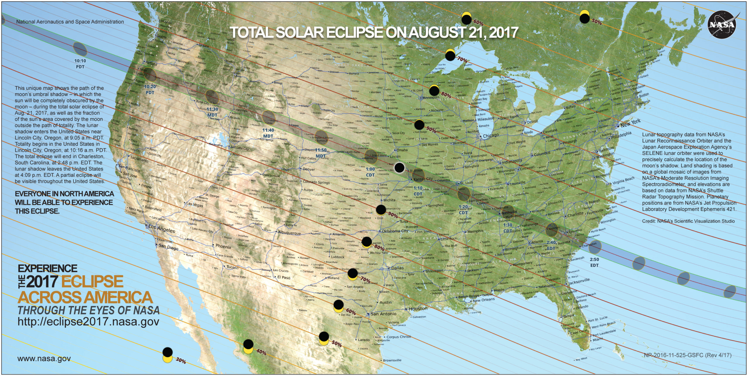

Although everyone in North America will be able to view an eclipse of the sun on Monday, August 21, 2017, there is a specific narrow swath approximately 70 miles wide from Portland in Oregon to Charleston in South Carolina under which a total eclipse of the sun can be viewed and offer the rare treat of being able to view the corona of the sun with the naked eye…
Total Solar Eclipse: Two Useful Tools to Know Where to Go
…and although some good information was imparted in this article which I wrote exactly one month ago, you might want to experience the total eclipse of the sun for as long as possible — but where exactly should you go?
The two tools which are highlighted in this article should help you find a precise location where you can enjoy the total eclipse of the sun.
Interactive Solar Eclipse Tool By ZIP Code
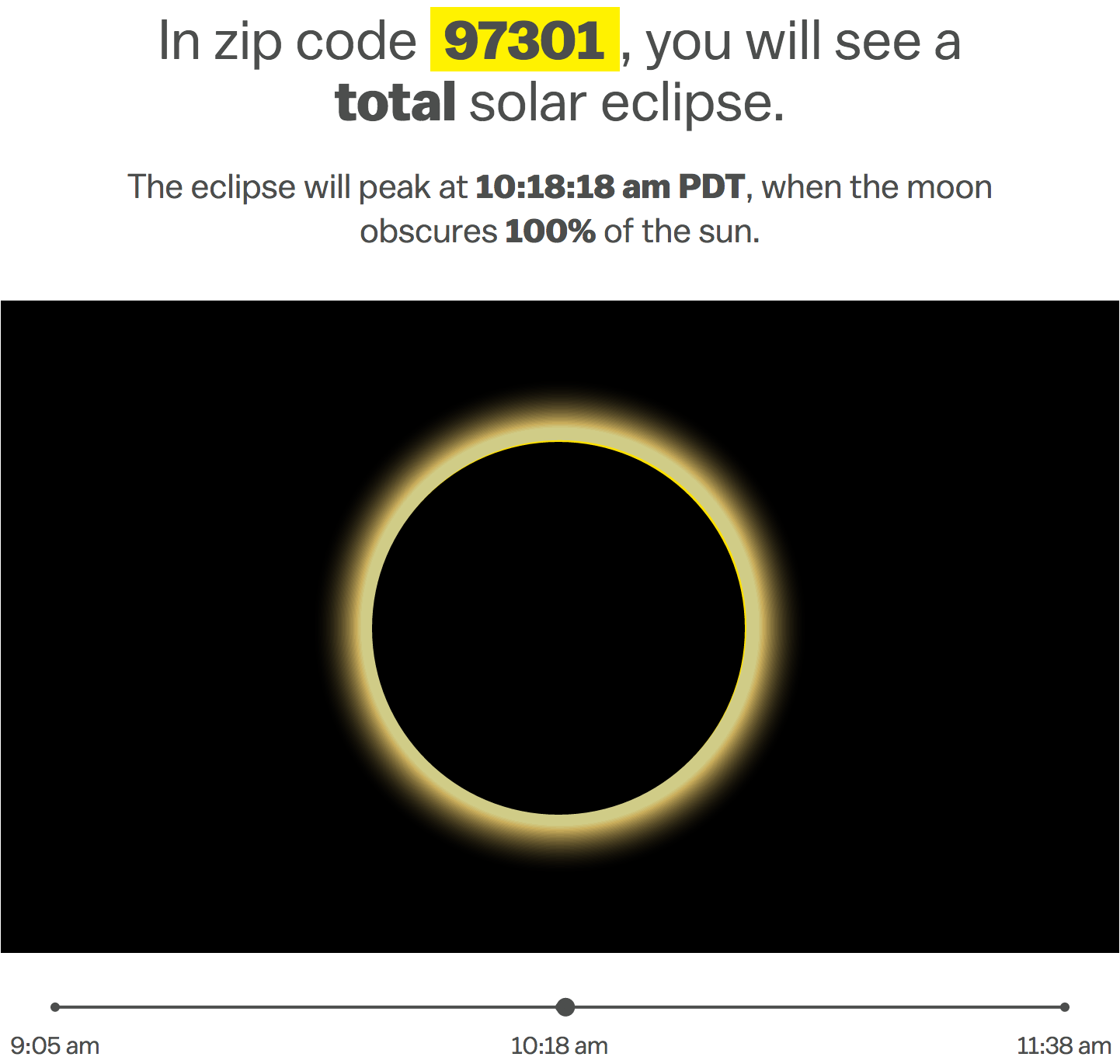

“The eclipse animation relies on data provided by The United States Naval Observatory and uses entering and exiting vertex angles along with the maximum obscuration percentage to calculate the trajectory of the moon across the sun. Maximum obscuration percentages in the animation are depicted using the nearest whole percent. The map obscuration data was provided by NASA”, according to this article written by
Using the tool in the aforementioned article, simply type in the ZIP code of where you intend to watch the eclipse to find out the peak time of the eclipse — as well as the percentage of how much the sun will be obscured by the moon.
By the way, did you know that ZIP is an acronym for Zone Improvement Plan?
Interactive Map
Although a special Internet web site was established by the National Aeronautics and Space Administration of the United States — which is more popularly known as NASA — devoted specifically to the total solar eclipse expected to occur next month offers plenty of information pertaining to where to go and how to safely view this celestial phenomenon, it does not offer a map to where you can zoom in to a satellite view of a specific spot as you can do with Google Maps.
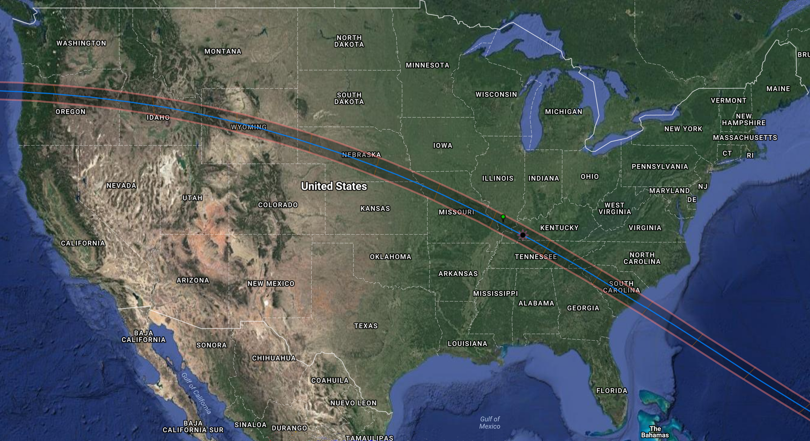

Using Google Maps as the engine and created by Xavier M. Jubier, this interactive map of the total solar eclipse is an excellent way for you to pinpoint the precise location of where to maximize your viewing of the total eclipse of the sun — as well as gather other information about the eclipse in any location in the United States with one single click.
There is even a green spot on the map — which is visible in the above illustration — that shows the precise location of where you can view the longest duration of the total solar eclipse:
Location of longest duration
37° 34′ 04.3″ N
89° 06′ 10.0″ W
239 m
2 min 41.6 sec
(ΔT=68.8s, DE405, Kaguya/LRO lunar limb profile)Located in Illinois, and not to be confused with the point of greatest eclipse located in Kentucky.
This location has the longest eclipse duration when the irregularities of the moon’s limb (due to mountains and valleys) are taken into account. Finally, the point of longest duration is not the same as the point of greatest eclipse.
Click here for specific instructions on how to most effectively use the interactive map.
Bonus: How to Photograph a Solar Eclipse
When you have pinned down the location as to where you want to photograph the solar eclipse, how do you take pictures of it?

“We asked two veteran photographers to share their top tips for documenting the biggest astronomical event America has seen in years”, according to this article written by
If you are unsure as to the best ways of photographing the solar eclipse, information in the aforementioned article includes researching the best locations; bringing the right equipment; getting creative with your photography — and even using your smartphone or other portable electronic device if you do not have the proper equipment.
Summary
If I stay put where I am based, I would be able to see almost 97.5 percent of the sun blocked by the moon during the eclipse; but I intend to drive approximately 130 miles away to view — and possibly photograph — the total eclipse of the sun.
Regardless of what happens, I intend to report on my experience in a future article.
Source: National Aeronautics and Space Administration of the United States.
