
Note: This article pertaining to Half of the Population of the United States Lives in 145 Counties — and a Great Custom Mapping Tool You Can Use was originally published on Monday, January 23, 2017 at 11:38 in the evening and has been updated.
One of the lofty goals which Dan Miller of Points with a Crew wants to accomplish is having been to every one of the 3,143 counties in the United States — but I wonder if he knew that approximately half the population of the United States resides in only 145 of those counties?
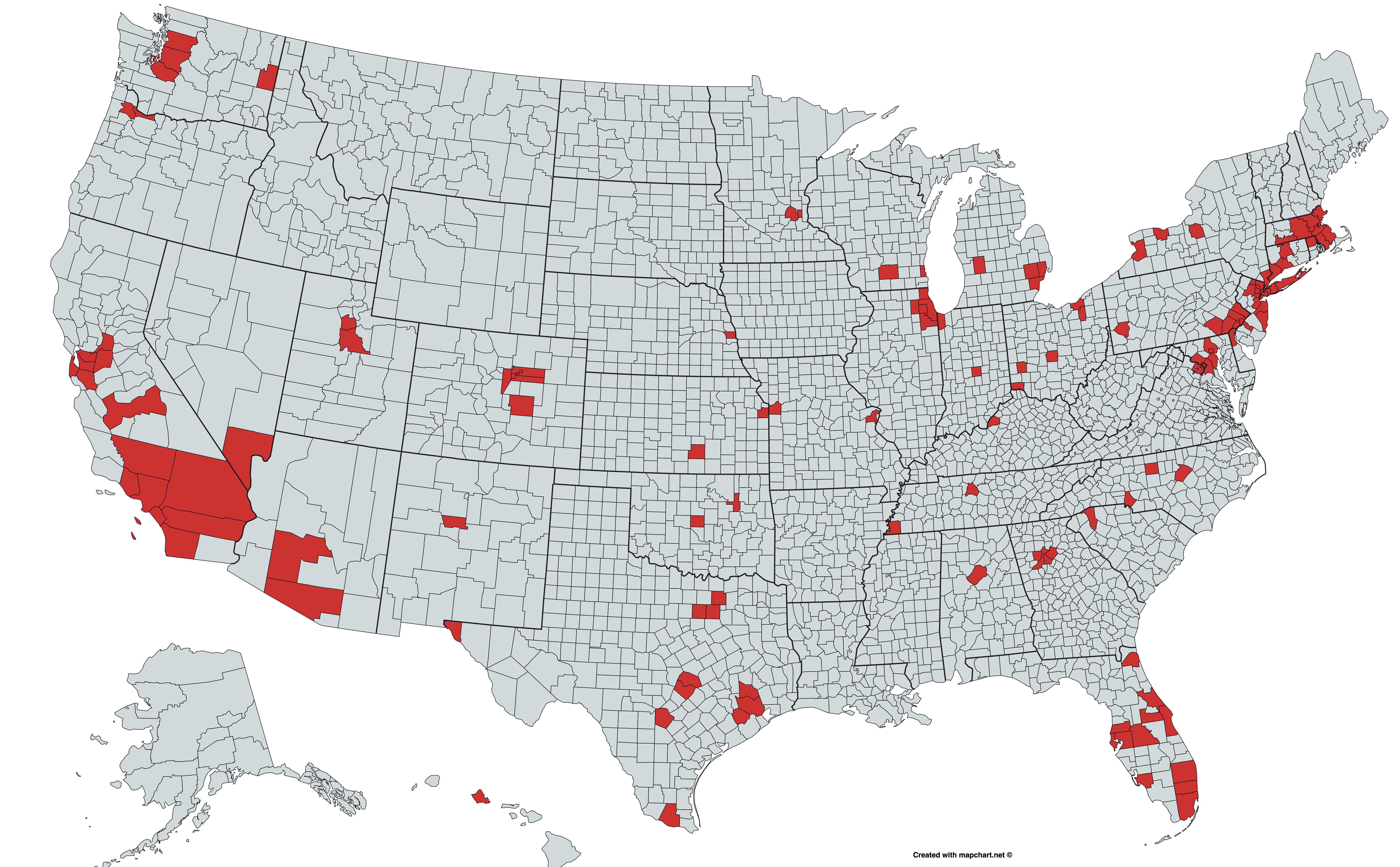
Half of the Population of the United States Lives in 145 Counties
Using data from the County Population Totals and Components of Change: 2020-2024 from the United States Census, the following list is of all 145 counties — or, technically, 144 counties plus the District of Columbia — that are listed in alphabetical order by state:
- Jefferson County, Alabama
- Maricopa County, Arizona
- Pima County, Arizona
- Alameda County, California
- Contra Costa County, California
- Fresno County, California
- Kern County, California
- Los Angeles County, California
- Orange County, California
- Riverside County, California
- Sacramento County, California
- San Bernardino County, California
- San Diego County, California
- San Francisco County, California
- San Joaquin County, California
- San Mateo County, California
- Santa Clara County, California
- Sonoma County, California
- Stanislaus County, California
- Ventura County, California
- Adams County, Colorado
- Arapahoe County, Colorado
- Denver County, Colorado
- El Paso County, Colorado
- Jefferson County, Colorado
- Fairfield County, Connecticut
- Hartford County, Connecticut
- New Haven County, Connecticut
- New Castle County, Delaware
- District of Columbia
- Brevard County, Florida
- Broward County, Florida
- Duval County, Florida
- Hillsborough County, Florida
- Lee County, Florida
- Miami-Dade County, Florida
- Orange County, Florida
- Palm Beach County, Florida
- Pasco County, Florida
- Pinellas County, Florida
- Polk County, Florida
- Volusia County, Florida
- Cobb County, Georgia
- DeKalb County, Georgia
- Fulton County, Georgia
- Gwinnett County, Georgia
- Honolulu County, Hawaii
- Cook County, Illinois
- DuPage County, Illinois
- Kane County, Illinois
- Lake County, Illinois
- Will County, Illinois
- Lake County, Indiana
- Marion County, Indiana
- Johnson County, Kansas
- Sedgwick County, Kansas
- Jefferson County, Kentucky
- Anne Arundel County, Maryland
- Baltimore County, Maryland
- Montgomery County, Maryland
- Prince George’s County, Maryland
- Bristol County, Massachusetts
- Essex County, Massachusetts
- Hampden County, Massachusetts
- Middlesex County, Massachusetts
- Norfolk County, Massachusetts
- Plymouth County, Massachusetts
- Suffolk County, Massachusetts
- Worcester County, Massachusetts
- Kent County, Michigan
- Macomb County, Michigan
- Oakland County, Michigan
- Wayne County, Michigan
- Hennepin County, Minnesota
- Ramsey County, Minnesota
- Jackson County, Missouri
- Saint Louis County, Missouri
- Douglas County, Nebraska
- Clark County, Nevada
- Bergen County, New Jersey
- Camden County, New Jersey
- Essex County, New Jersey
- Hudson County, New Jersey
- Middlesex County, New Jersey
- Monmouth County, New Jersey
- Morris County, New Jersey
- Ocean County, New Jersey
- Passaic County, New Jersey
- Union County, New Jersey
- Bernalillo County, New Mexico
- Bronx County, New York
- Erie County, New York
- Kings County, New York
- Monroe County, New York
- Nassau County, New York
- New York County, New York
- Onondaga County, New York
- Queens County, New York
- Richmond County, New York
- Suffolk County, New York
- Westchester County, New York
- Guilford County, North Carolina
- Mecklenburg County, North Carolina
- Wake County, North Carolina
- Cuyahoga County, Ohio
- Franklin County, Ohio
- Hamilton County, Ohio
- Montgomery County, Ohio
- Summit County, Ohio
- Oklahoma County, Oklahoma
- Tulsa County, Oklahoma
- Multnomah County, Oregon
- Washington County, Oregon
- Allegheny County, Pennsylvania
- Bucks County, Pennsylvania
- Chester County, Pennsylvania
- Delaware County, Pennsylvania
- Lancaster County, Pennsylvania
- Montgomery County, Pennsylvania
- Philadelphia County, Pennsylvania
- Providence County, Rhode Island
- Greenville County, South Carolina
- Davidson County, Tennessee
- Shelby County, Tennessee
- Bexar County, Texas
- Collin County, Texas
- Dallas County, Texas
- Denton County, Texas
- El Paso County, Texas
- Fort Bend County, Texas
- Harris County, Texas
- Hidalgo County, Texas
- Montgomery County, Texas
- Tarrant County, Texas
- Travis County, Texas
- Williamson County, Texas
- Salt Lake County, Utah
- Utah County, Utah
- Fairfax County, Virginia
- King County, Washington
- Pierce County, Washington
- Snohomish County, Washington
- Spokane County, Washington
- Dane County, Wisconsin
- Milwaukee County, Wisconsin
Bonus: A Great Custom Mapping Tool You Can Use
During my research, I stumbled upon a tool called Mapchart.net, which I used to fill the counties in red in the map you see at the top of this article. With it, you can create your own custom map of the world, continents, countries, territories, states, counties and more with colors and descriptions of your choice. I found it to be rather accurate and fairly easy to use.
Here is the map again so that you may click on it for an enlarged view.

You can also visit the counties view of a map of the United States at mapchart.net and hover your cursor over each county to find out the specific name of each county.
Final Boarding Call
I have always been interested — and mesmerized — with maps of all types; so I was naturally drawn to the information used in this article.

Having been to every one of the 3,143 counties in the United States does not interest me personally as a travel goal, as I am having a difficult enough time trying to have been in every country in the world.
I have already been to every continent in the world and to all 50 states in the United States, though…
Map created with mapchart.net.
