
Set on the idyllic southwestern part of Easter Island adjacent to the cerulean waters of the Pacific Ocean lies Rano Kau, which generally means “a large or wide volcano with an abundance of water” and is a natural phenomenon in and of itself — and although the sensation of vastness and tranquility will be interrupted only by the wind; the distant sound of the waves; and the occasional squawking of seabirds, concerns of an explosive eruption of hot molten lava is unlikely, considering that the last eruption is estimated to have occurred approximately 180,000 years ago.
Visiting The Largest Volcano Crater on Easter Island: Rano Kau
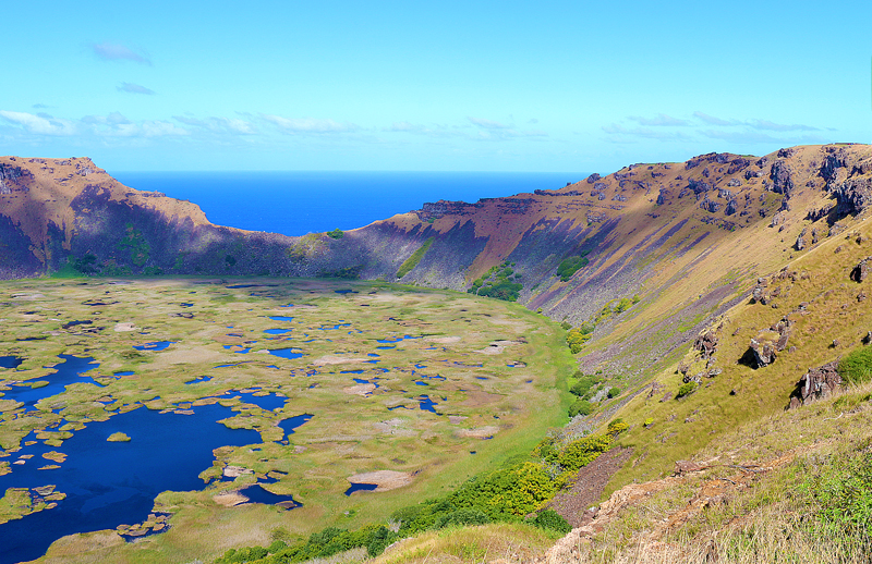
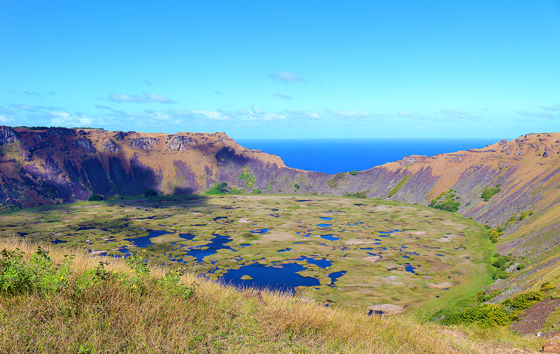
Rano Kau — which is the largest volcano crater on Easter Island with an immense caldera of 1.6 kilometers in diameter — has its own ecosystem; and its microclimate creates a natural greenhouse effect, with favorable humidity and lighting conditions for the development and cultivation of many species of vegetation and a rich diversity of flowers within it which is unique to the island. It is considered to be the last haven of biodiversity in Rapa Nui. Additionally, the walls of Rano Kau are greater than 200 meters tall, which protects most of the interior of the volcano crater from the strong and unrelenting winds and the salinity of the sea — as well as from human beings, cattle, and the danger of fire.
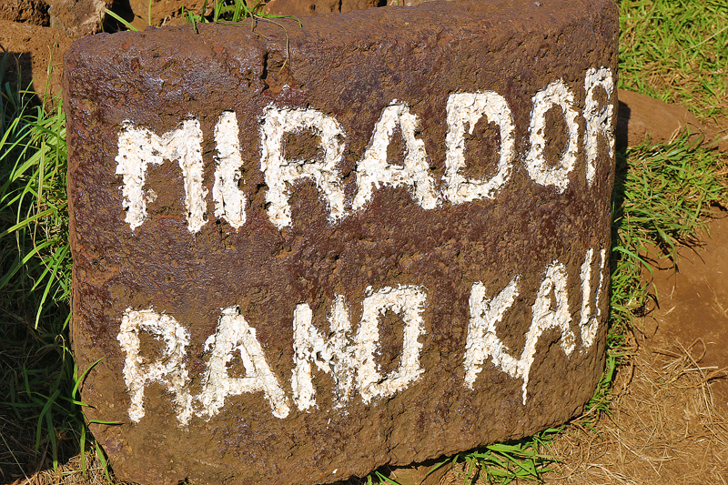
Access to the observation point of Mirador Rano Kau — which is one of the best ways to view the crater — is either by walking along the path that ascends the northern slope; or by vehicle which can be parked in the parking lot.
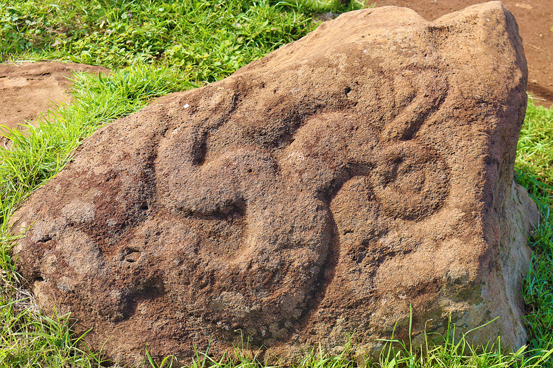
Located only a few meters from the viewpoint is a small rock surrounded by trunks at which you can see several silhouettes of the bird-man known as Tangata Manu. This is a preview of only one of the many similar petroglyphs that can be seen in the nearby ceremonial village of Orongo, which is approximately one kilometer away and can be easily accessed by either a walk of approximately 15 minutes along a special path — or by motor vehicle, if you prefer.
In addition to petroglyphs, caves, foundations of houses, and even remains of ahu — or platforms — have been found in the interior and exterior of the Rano Kau volcano crater.
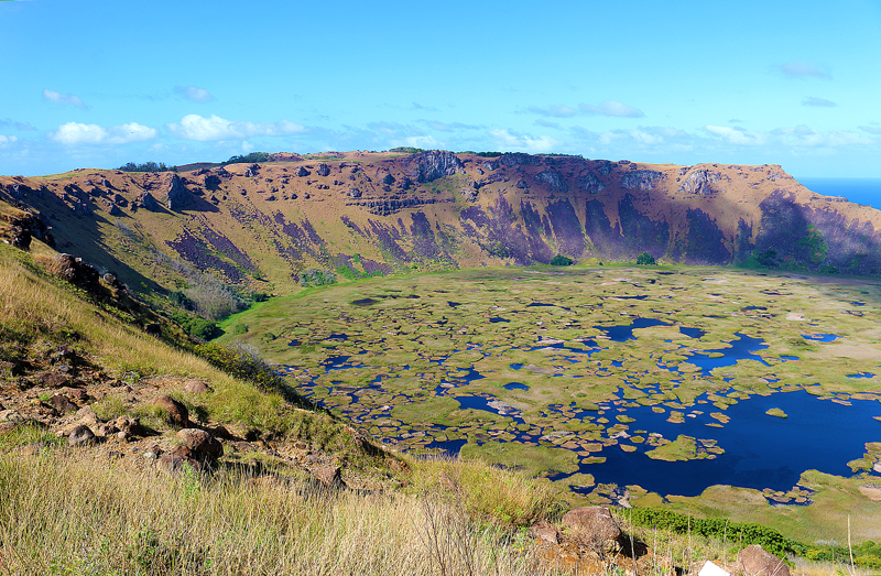
Rapa Nui is a small and remote triangle of earth which consists of Rano Kau and two other main volcanic cones — and is located only a few kilometers south of Hanga Roa, which is the main town where approximately 87 percent of the total population of Easter Island resides. In fact, the base of the north side of Rano Kau — which faces the interior of Easter Island — practically abuts the runway of Mataveri International Airport; while substantial marine erosion over thousands of years contributed to the formation of vertigo cliffs which reach a height of approximately 300 meters on the south and southwest sides of Rano Kau…
…and visitors can see the obvious “bite” which looks like has been taken out of the volcanic wall, which is known as Kari Kari. This is where the numerous flows of basaltic lavas — which were estimated to have begun approximately 2.5 million years ago and formed the volcano — spilled into the Pacific Ocean. The continuous onslaught of the waves of the ocean may result in the collapse of this fragile wall, which will allow access to inside the immense crater from the sea.
A large lagoon of sorts — whose diameter is approximately 1.5 kilometers — was formed by the accumulation of rainwater inside the large caldera of Rano Kau; and the shore is located approximately 200 meters from the upper edge of the volcanic crater. The depth of the lake is estimated to be 10 meters; and its surface is covered to a large extent by a plethora of floating islands of totora reeds, which are very unstable due to their thickness of only one meter.
Up until a few decades ago, this lagoon was one of the available main sources of fresh water to the inhabitants of Easter Island, which does not have such permanent water courses as rivers and streams. The activity of humans was developed mainly alongside the small inland lakes of Rano Kau, Rano Raraku — which can only be visited once and will be covered in a future article here at The Gate — and Rano Aroi, apart from other settlements near some springs and small ponds which were formed in volcanic rocks.
At one time long ago, a variety of exotic trees and shrubs were planted in terraces built on the inner slopes of Rano Kau. Other species of vegetation were eventually introduced — such as bananas, fig trees, guavas, grapevines, avocados, and tubers as six of numerous examples.
According to legend, Hotu Matu’a — who was the first king — chose to spend his last days on the southeast side of the crater after his wife Vakai passed away. When he felt his death approaching, Hotu Matu’a went to the aforementioned sacred site of Orongo and looked with nostalgia towards the horizon on the islet of Motu Nui, remembering his homeland of Hiva.
Final Boarding Call
Rano Kau is located on the southwestern coast of Easter Island slightly greater than six kilometers south of Hanga Roa. Driving there is easy, as the entrance is marked well. The fastest route is to take the road which goes around the western part of the international airport and turn right. You will pass by one of the only two fuel stations on the island and simply continue all the way up until you reach the small parking lot where you can park and leave your vehicle. You can also ascend the steep climb of Rano Kau by bicycle or by walking along the same road.

Remember that Rano Kau is part of Parque Nacional Rapa Nui — which is the national park of Easter Island — and you must present your ticket at the checkpoint prior to entering. You will need to pay $100.00 in United States dollars just for admission into the areas of the national park; and the ticket may be purchased either on arrival at the airport or in the center of town of Hanga Roa, which is the only municipality on Easter Island.
Note that you can only visit Orongo — which will be covered in a future article here at The Gate — once; so keep that in mind when visiting Rano Kau.
Ensure that you please leave cultural features exactly as you find them during your visit.
Other articles pertaining to Easter Island include:
- Easter Island: Itinerary and Master Guide [Work In Progress]
- The Largest Statue Ever Moved and Successfully Erected on Easter Island: Ahu Te Pito Kura
- Easter Island is Not Only Statues: Ana Te Pora Lava Tunnel
- What You Need to Know About Renting a Vehicle and Driving on Easter Island
- Dogs Versus Horses on Easter Island
- Road Trip Around Easter Island
All photographs ©2019 by Brian Cohen.
